Zion vs Bryce Canyon: Which Utah Icon Is Right for You?
Zion drops you into slot canyons with permit lotteries. Bryce lifts you to 8,000 feet where hoodoos cluster like a stone forest
Zion and Bryce Canyon sit just over 80 miles apart in southern Utah, close enough to see both in a few days but different enough that planning matters. Zion plunges you into red rock canyons where the Virgin River cuts through sandstone walls taller than any building you've stood next to. Bryce lifts you to 8,000 feet where orange spires called hoodoos cluster so densely you can't see the forest floor from the rim. One is a slot canyon hike through water. The other is a high-altitude maze of rock towers. You can do both, but you should know which one gets your extra day.
Zion National Park
Draws more people than Yellowstone / Red walls rise 2,000 feet above the Virgin River
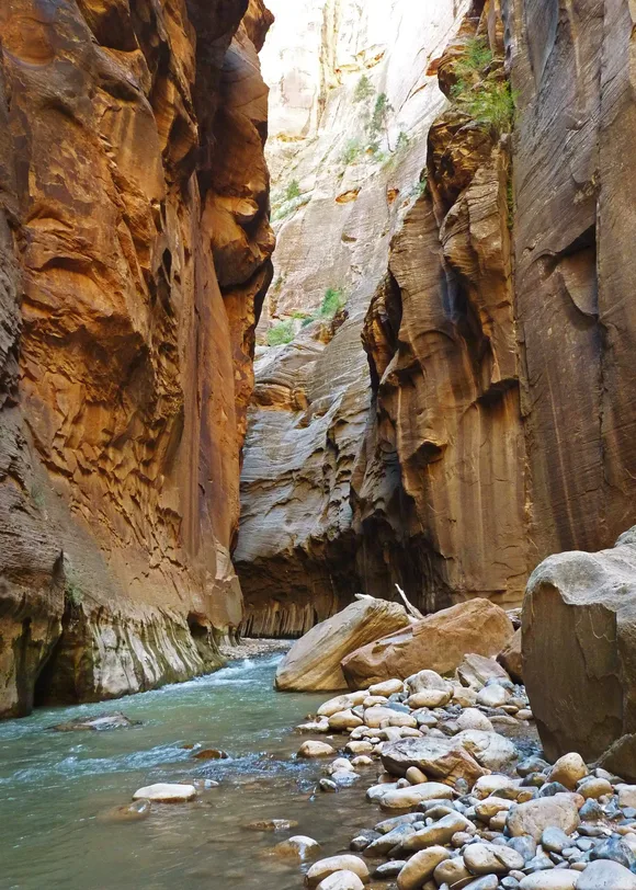
Zion Canyon funnels almost everyone through the same narrow corridor, and the result is shoulder-to-shoulder traffic at Angels Landing and lines for the shuttle that start before sunrise in peak season. The park's fame comes from two hikes: Angels Landing's chain-assisted climb to a fin of rock with 1,000-foot drops on both sides, and The Narrows, where you wade upstream through chest-deep water between walls so tight you lose the sky. Both are spectacular. Both require permits or lottery wins during summer. Both will put you in a crowd.
The Virgin River carved Zion so narrow that 16 miles of canyon can barely fit a two-lane road.
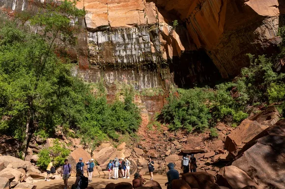
If you skip the famous two, Zion opens up. Observation Point via East Mesa gives you the same sweeping canyon view as Angels Landing without the chains or the lottery. Canyon Overlook Trail takes 20 minutes and delivers a perspective most visitors never see. The Subway requires technical canyoneering skills and a permit, but it's the park's most otherworldly feature: a tube of rock polished smooth by water, glowing amber when the light hits right. Zion rewards the effort to look past the brochure, but you have to accept that the shuttle will be packed and the trailheads will be busy even in shoulder season.
Bryce Canyon National Park
Half the size of Zion but twice the elevation / Earth's densest hoodoo forest
Bryce isn't technically a canyon. It's the edge of a plateau where erosion carved an amphitheater of orange and white spires that look like a fantasy city designed by water and frost. The rim sits at 8,000 feet, which means cooler temperatures than Zion even in July and snow that lingers into April. Most people drive the 18-mile scenic road, stop at Sunrise and Inspiration Points, take a photo, and leave. The real experience is dropping below the rim on the Navajo Loop, where you descend through switchbacks into a forest of hoodoos so tall and tightly packed you'll touch rock on both sides as you walk.
Walking among Bryce's hoodoos feels like wandering through a cathedral built by geology instead of architects.
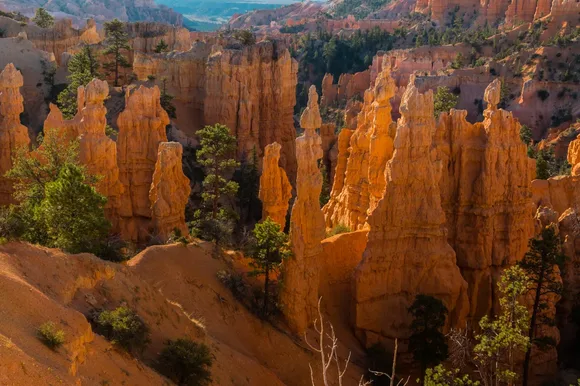
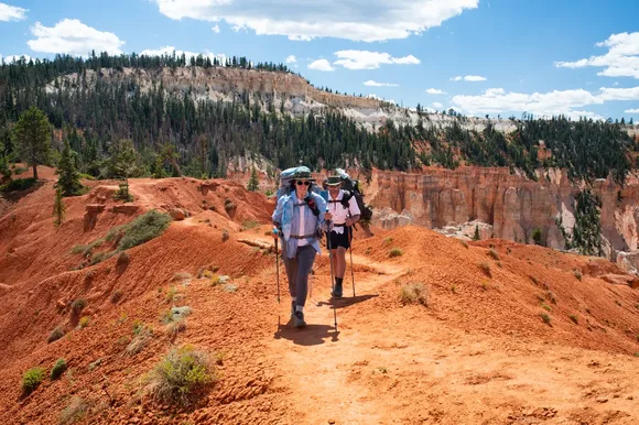
Queen's Garden Trail connects to the Navajo Loop for a three-mile loop that takes you from rim to canyon floor and back, passing hoodoos named for their shapes: Thor's Hammer, Queen Victoria, Wall Street. The light changes every hour, turning the rock from pale orange at dawn to deep red at sunset. Bryce absorbs crowds better than Zion because the rim trail spreads people across 13 viewpoints instead of funneling everyone into one canyon. September brings the biggest crowds, but even then you'll find stretches of trail where the only sound is wind through ponderosa pines.
Getting There and Timing Your Trip
Las Vegas sits 160 miles from Zion, making it the closest major airport for most visitors. St. George is closer to Bryce at 60 miles, but fewer flights land there. If you're doing both parks, drive the scenic route through Mount Carmel Junction on Highway 89, which connects the two in about two hours. Zion peaks in June when the weather turns hot and the shuttle system strains under the load. Bryce peaks in September when the aspens turn gold and temperatures drop into comfortable hiking range. April and May give you the best of both: Zion before the summer crush and Bryce after the snow melts but before the crowds arrive.
Zion stays open year-round, but winter narrows your options. The Narrows closes when the river runs too cold or too fast, and Angels Landing becomes a scramble over ice without the summer permit headaches. Bryce in winter transforms into a cross-country skiing destination where you can glide along the rim trail with hoodoos dusted in snow. Most park roads stay plowed, but trails below the rim turn icy and require microspikes by December.
The Verdict
Choose Zion if you want the iconic hike you've seen in every Utah travel photo, if you're comfortable with crowds and shuttle logistics, or if wading through a slot canyon sounds better than walking among rock spires. The park demands more planning and patience, but Angels Landing and The Narrows deliver the kind of experience that justifies the hassle.
Choose Bryce if you prefer high-altitude hiking over desert heat, if you want a park that's easier to navigate and less congested at trailheads, or if you've never seen hoodoos and want geology that looks like nothing else on the continent. Bryce is smaller, cooler, and more forgiving for visitors who didn't book six months ahead.
Or do both. Zion deserves two full days if you're hiking the big trails. Bryce works as a day trip if you're pressed for time, though staying for sunrise and sunset will give you the light that makes the hoodoos glow. The drive between them takes you through red rock country that's worth the detour, and you'll leave Utah understanding why this corner of the state draws comparisons to another planet.