Hurricane Nolo closes Hawaii Volcanoes National Park — what visitors need to know after the storm
Hurricane Nolo closed Hawaii Volcanoes for four days. Here's what reopened, what's still damaged, and what visitors need to know
Hurricane Nolo swept past the Big Island on October 22, forcing Hawaii Volcanoes National Park to close for the first time in years. The park reopened four days later with damage to trails, roads, and visitor facilities still being assessed. If you're planning a visit this fall or winter, here's what changed and what you need to know before you arrive.
The storm brought sustained winds over 70 mph and dumped more than eight inches of rain across the summit area in 24 hours. That's unusual even for a park that sits in the path of Pacific weather systems. Chain of Craters Road took the worst of it, and while crews cleared debris quickly, some trails remain closed indefinitely.
Hawaiʻi Volcanoes National Park
Two active volcanoes still reshaping the landscape / Chain of Craters Road partially reopened
The park's defining feature is that it's still being built. Kīlauea has erupted 34 times since 1952, most recently filling the summit caldera with a lava lake that glows red at night when the volcano cooperates. Hurricane Nolo didn't touch the volcanic activity, but it damaged infrastructure visitors rely on to see it safely. The Crater Rim Trail, which loops around Kīlauea Caldera for 11 miles, lost sections of boardwalk and railing near Steam Bluffs. Park Service crews estimate repairs will take through November, possibly into December depending on volcanic activity.
You're walking on rock that didn't exist when your parents were born, watching the earth remake itself in real time.
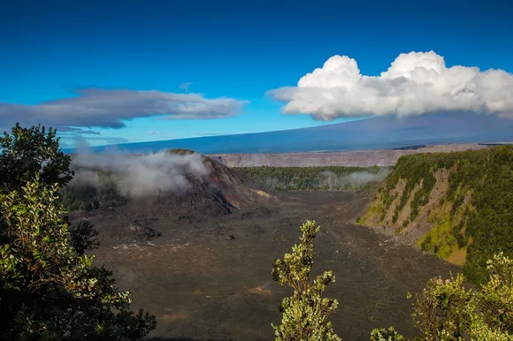
Chain of Craters Road, the 19-mile descent from the summit to the coast, reopened October 26 but only to the Maunaulu parking area at mile 3.5. The lower section, which used to end abruptly where lava buried the pavement in 2018, remains closed while crews assess culverts and bridges. That cuts off access to the Holei Sea Arch and the petroglyphs at Puʻu Loa, two of the park's most distinctive coastal features. The National Park Service hasn't committed to a timeline for full reopening, citing ongoing inspections.
Thurston Lava Tube, the park's most visited single feature, emerged unscathed. The 0.3-mile loop through the 500-year-old tunnel stayed open throughout the storm, though the surrounding rainforest lost dozens of ʻōhiʻa trees. Expect downed branches and muddy conditions on the approach trail through at least mid-November. The parking lot, which fills by 10 AM even on slow days, may actually have space now that Chain of Craters Road is partially closed and diverting fewer people to the summit area.
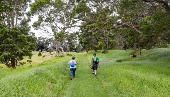
Kīlauea Iki Trail, a four-mile loop that descends 400 feet into a crater that erupted in 1959, took water damage but remains open. The trail crosses a solidified lava lake that still steams in places where rainwater seeps through cracks and hits hot rock below. Hurricane Nolo turned sections of the crater floor into temporary ponds, and while the water drained within 48 hours, the crossing remains slick with mud. Rangers recommend waiting until late October or early November for conditions to dry out, especially if you're hiking with kids who might struggle with the steep switchbacks on the return climb.
The two campgrounds, Nāmakanipaio and Kulanaokuaiki, reopened October 27 with some sites still offline. Nāmakanipaio, the larger of the two at 4,000 feet elevation, lost power during the storm and ran on generators for three days. Most sites are now operational, but the showers and laundry facilities won't return until at least November. Kulanaokuaiki, a more primitive option near the coast, suffered flooding in the lower loop and remains partially closed. If you're planning to camp, call ahead or check the park's website for real-time site availability.
Backcountry permits, required for overnight trips to Mauna Loa's summit or the coastal campsites, are being issued again but with restrictions. The Mauna Loa Summit Trail, a 15.2-mile climb to 13,679 feet, is open but rangers warn that storm damage to the cabins at Red Hill and the summit hasn't been fully assessed. The cabins are still available on a first-come basis, but expect leaks and missing shutters. Coastal campsites at ʻĀpua Point and Kaʻaha remain closed indefinitely due to storm surge damage and debris.

Weather in October and November is typically the park's most comfortable window. Daytime highs hover in the low 70s at the summit, nighttime lows drop into the mid-50s, and afternoon rain showers are brief rather than the all-day soakers common in winter. Hurricane Nolo shifted that pattern slightly. The storm brought cooler air behind it, and early reports suggest November may run a few degrees below average. That's good news if you're planning to hike Mauna Loa, where temperatures can swing 30 degrees between the trailhead and the summit, but it means summit viewpoints like Kīlauea Overlook will be chillier than usual at sunrise.
Visitor centers took minor damage but are fully operational. The Kīlauea Visitor Center, near the park entrance, reopened October 26 with regular hours. Rangers are running programs again, including the popular After Dark in the Park evening talks that cover everything from volcanic geology to Hawaiian cultural history. The Thomas A. Jaggar Museum, closed since 2018 due to earthquake damage, remains shuttered with no reopening date. That's unrelated to the hurricane, but worth noting since older maps and guides still list it as a major stop.
The park draws more than 1.4 million visitors a year, most of them concentrated in December and January when winter travel to Hawaii peaks. October typically sees lighter crowds, and post-hurricane closures have thinned them further. If you're visiting in the next few weeks, you'll likely have trails and viewpoints more to yourself than usual, especially midweek. By late November, as word spreads that the park is mostly open again, expect numbers to climb back toward normal.
One wildcard is volcanic activity. Kīlauea's summit eruptions are unpredictable, and while the lava lake has been active intermittently since December 2020, it can pause for weeks or months without warning. When it's flowing, the glow is visible from Devastation Trail and the Kīlauea Overlook parking area, both short walks from the main road. When it's not, you're left with a smoking crater and the sulfur smell that never quite goes away. Rangers update the eruption status daily on the park website and at the visitor center, so check before you drive out to the overlooks.