8 Parks at Their Best Right Now
Eight national parks where September brings better weather, fewer crowds, and the kind of breathing room that summer never offers
Summer vacation ends and the national parks exhale. September clears out the peak season crowds while keeping the weather cooperative, and a handful of parks hit their stride precisely when most visitors have gone home. These eight parks trade the summer crush for cooler temps, thinner trail traffic, and the kind of elbow room that reminds you why public lands matter in the first place.
You won't find Yellowstone or Yosemite on this list. Those parks are spectacular in September, but you already know about them. These are the places that most people overlook until they stumble into them by accident and kick themselves for waiting so long.
Channel Islands National Park
Five islands 12 miles offshore / Fewer visitors than most state parks
California's coast holds one of the least visited parks in the system, and September delivers the weather window that makes it accessible. The summer fog finally burns off, ocean swells calm down enough for reliable boat crossings, and the water temperature hits its annual peak in the mid-60s. You'll share Santa Cruz Island with maybe a few dozen other people instead of the shoulder-to-shoulder crowds you'd find at any mainland beach.
The boat ride to Anacapa takes 90 minutes, and half the passengers on board have never heard of the place they're visiting.
The Prisoner's Harbor to Chinese Harbor Trail cuts across the island's north coast through grasslands that turn golden in fall, dropping into sea caves and coves where harbor seals haul out on the rocks. Island foxes the size of house cats trot across the trail without much concern for humans. Kayakers paddle the sea caves along the coast while snorkelers chase garibaldi through kelp forests that rival anything in the tropics. The ranger programs cover everything from endemic species to Chumash history, and the night sky looks like someone spilled glitter across black velvet.
Cuyahoga Valley National Park
More visitors than Bryce Canyon / 20 miles of canal towpath
Ohio's only national park sits between Cleveland and Akron, threading the Cuyahoga River valley with trails that follow an 1820s canal route. September brings the first hints of fall color to the hardwood forests and drops the humidity that makes July feel like breathing through a wet towel. The Towpath Trail runs flat and paved for 20 miles, perfect for bikes or strollers, while the Ledges Trail climbs through rock formations that glaciers carved 12,000 years ago.
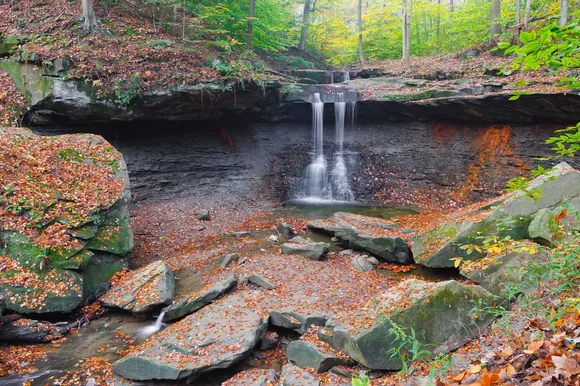
Brandywine Falls drops 65 feet into a moss-lined gorge that stays cool even when the parking lot bakes in afternoon sun.
You can knock out the Brandywine Falls Trail in 20 minutes round trip, but the Ledges Trail rewards the extra effort with slot canyons and rock shelters that feel transported from Utah. The Cuyahoga Valley Scenic Railroad runs vintage trains through the park on weekends, and you can bike one direction on the towpath and ride the train back. Kids chase frogs in the beaver ponds along Goose Pond Trail while birders tick off migratory warblers that funnel through the valley.
Great Basin National Park
Five hours from the nearest city / More solitude than almost anywhere
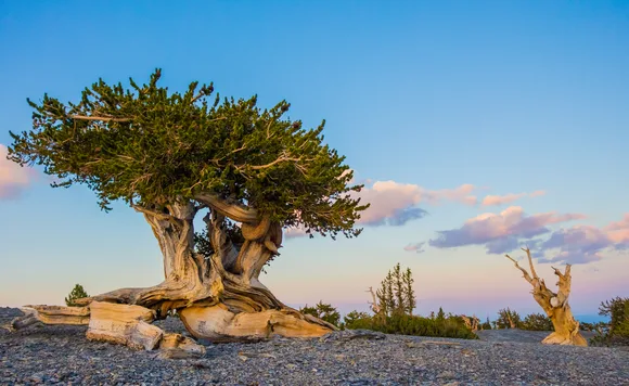
Nevada's least visited park peaks in September when the high country cools down and the aspens start turning gold against Wheeler Peak's limestone face. Most people have never heard of Great Basin, which means you can hike to alpine lakes at 10,000 feet without passing another soul. The Bristlecone Pine Trail climbs through trees that were already ancient when Rome fell, gnarled survivors clinging to exposed ridges where nothing else grows.
Wheeler Peak rises from the basin floor like a fortress, holding snow in its cirques well into summer and gathering it again by October.
Lehman Caves stay a constant 50 degrees year-round, dripping with formations that rival Carlsbad without the elbow-to-elbow tours. The Wheeler Peak Trail gains 3,000 feet in less than five miles, topping out at the glacier and summit ridge where you can see across half of Nevada. September brings stable weather patterns and clear skies that make the drive up Wheeler Peak Scenic Drive less of a white-knuckle experience. The stargazing ranks among the darkest skies in the Lower 48, and the ranger programs cover everything from cave geology to Ice Age history.
Great Sand Dunes National Park & Preserve
Tallest dunes in North America / Sand temps drop 50 degrees from July
Colorado's pile of sand reaches its prime after Labor Day when surface temperatures drop from scalding to merely warm and the afternoon thunderstorms taper off. The dunes rise higher than the Washington Monument against the Sangre de Cristo Mountains, creating a landscape that looks Photoshopped until you're standing in it. September brings cool mornings perfect for hiking the sand and warm afternoons for wading Medano Creek if late-season snowmelt keeps it flowing.
High Dune sits three miles from the parking lot, but every step forward slides you half a step back through sand that remembers nothing.
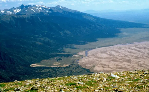
Most visitors stop at the first ridge, but Star Dune rewards the extra effort with 360-degree views and solitude that feels impossible this close to a parking lot. The alpine lakes in the Sangres hold cutthroat trout and frame the dunes from above, accessible via Mosca Pass Trail or the Sand Ramp route. Kids treat the dunes like a giant sandbox, rolling down slopes and digging holes that fill back in overnight. The night sky turns the sand silver under moonlight, and shooting stars streak across the Milky Way like someone's showing off.
Guadalupe Mountains National Park
Texas's highest peak / Cooler than anywhere else in the state
West Texas holds the fossilized remains of an ancient reef that rose from the ocean 265 million years ago, and September marks the beginning of the best hiking season in the Southwest. The Chihuahuan Desert cools down from blast furnace to merely warm, and the high country forests start hinting at fall color that peaks in October. McKittrick Canyon becomes the most beautiful spot in Texas when the bigtooth maples turn red against limestone walls.
Guadalupe Peak Trail gains 3,000 feet in four miles, topping out at the highest point in Texas where you can see into three states.
The park sits in the middle of nowhere by design, which means you'll share the trails with maybe a dozen other hikers even on weekends. Devil's Hall Trail winds through a narrow canyon to a natural staircase carved by water, while the Salt Basin Dunes shimmer white against the mountain's western face. The fossil reef holds more marine life than anywhere outside a museum, and the ranger programs explain how seashells ended up at 8,000 feet. You can camp in the backcountry without seeing another tent, and the night sky shows stars that city dwellers forget exist.
Haleakalā National Park
Summit at 10,000 feet / Sunrise reservations not required after August
Maui's dormant volcano draws crowds for sunrise, but September drops the mandatory reservation system and thins the pre-dawn traffic to something almost manageable. The summit hovers above the clouds where temperatures stay in the 50s year-round, offering a break from the beach heat below. The Sliding Sands Trail descends into a volcanic crater that looks more like Mars than Hawaii, dropping through cinder cones and lava formations that glow red and yellow against black sand.
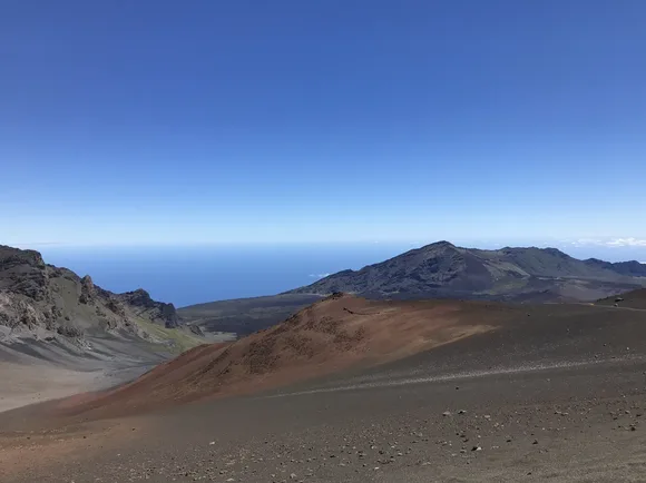
You drive from sea level to alpine desert in 90 minutes, climbing through ecosystems that shift like chapters in a geology textbook.
The Kīpahulu section sits two hours away on the island's wet side, where waterfalls cascade through bamboo forests and tide pools fill with tropical fish. The Pipiwai Trail climbs through groves that creak in the wind, ending at Waimoku Falls dropping 400 feet down a basalt cliff. September brings fewer tour buses and better odds of clear summit views before afternoon clouds roll in. The silversword plants bloom through October, turning the crater slopes silver with rosettes that take 20 years to flower once and die.
Hawaiʻi Volcanoes National Park
Two active volcanoes / Walk across lava from the 1950s
The Big Island's volcanic heart runs hot year-round, but September brings the most comfortable hiking weather between the spring crowds and winter's peak season. Kīlauea Caldera still steams from vents along Crater Rim Trail, and the lava fields stretch black and barren toward the ocean where new land forms whenever Mauna Loa wakes up. The Thurston Lava Tube drops into a cool tunnel carved by molten rock, emerging into rainforest dripping with ferns.
Kīlauea Iki Trail crosses a crater floor that was a lava lake in 1959, now cooled to a moonscape where steam vents hiss between hardened rock.
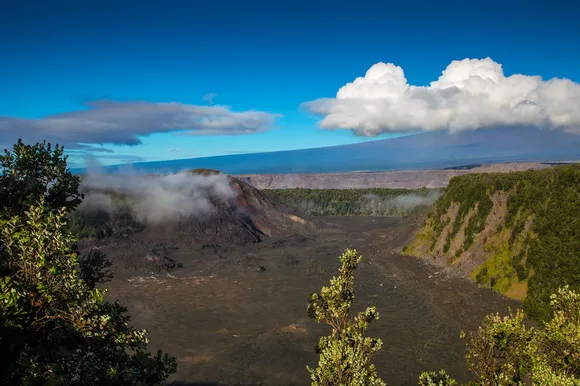
Chain of Craters Road descends 3,700 feet to the coast through lava flows dated by roadside markers, passing petroglyphs and steam vents that smell like sulfur. The Mauna Loa Summit Trail climbs to the world's largest volcano for backpackers willing to handle the altitude, but most visitors stick to the lowland trails through native ʻōhiʻa forests and recent eruption zones. September typically brings drier weather to the summit area while keeping the rainforest side green and dripping. The ranger programs cover volcanic processes, native ecology, and Hawaiian cultural history in equal measure.
Indiana Dunes National Park
Lake Michigan's southern shore / More plant diversity than Yellowstone
Indiana's stretch of Lake Michigan coastline became the country's newest national park in 2019, and September delivers the best beach weather without the summer crowds that pack Chicago's closest escape. The dunes rise 200 feet above the waterline, holding more plant species than parks 20 times their size. Mount Baldy shifts 20 feet per year as wind reshapes the dune, while Miller Woods preserves one of the last intact dune successions on the Great Lakes.
The Dunes Succession Trail demonstrates how bare sand becomes forest in fast-forward, walking through ecological time zones in three miles.
West Beach draws families who swim in water that stays swimmable through September while the air cools to the 70s. The wetlands behind the dunes fill with migrating birds funneling south along the lake, and the Bailly-Chellberg Trail passes through homesteads that date to the 1820s. You can bike the beach trail, kayak the rivers that feed into the lake, or climb Mount Jackson for views that stretch to Chicago's skyline on clear days. The Junior Ranger programs keep kids engaged while adults soak up the last warmth of summer without the parking lot chaos.