8 national parks with the most space per visitor
Eight parks where visitors per square mile drops to near zero and wilderness absorbs you instead of crowding you out
Space matters in a national park. Not the Instagram vista or the headline feature, but the simple geometry of acres per person. When a park the size of Connecticut averages fewer than one visitor per square mile, you get something most Americans have never experienced: wilderness that absorbs you instead of crowding you out.
These eight parks offer the most elbow room in the system. Some require floatplanes or multi-day backpacks to reach. Others sit three hours from major cities but somehow stay empty. All of them measure their visitors in thousands while Yellowstone counts millions. If you're tired of permit lotteries and dawn alarm clocks just to see a trailhead, this is where the math works in your favor.
Gates Of The Arctic National Park & Preserve
Larger than Switzerland / No trails, no roads, no campgrounds
This is the only national park in America with zero maintained trails. The Brooks Range rises through valleys that have never seen a footbridge or trail marker, and the National Park Service intends to keep it that way. You navigate by topographic map and river corridor, following caribou routes that predate human presence in North America. The park absorbs fewer visitors annually than Zion sees on a summer afternoon, spread across terrain so vast that you could hike for weeks without crossing another person's path.
Gates of the Arctic doesn't have visitors so much as participants willing to meet it on its own terms.
June brings near-constant daylight and the start of the brief Arctic summer. Dall sheep move to high ridges, and the tundra blooms in compression, cramming an entire growing season into eight weeks. Most people fly into Bettles and charter a floatplane deeper into the park, landing on gravel bars or remote lakes. You'll need genuine backcountry skills here, the kind that go beyond following cairns. River crossings, bear protocol, and navigation without trails are prerequisites, not suggestions.
Katmai National Park & Preserve
North America's densest brown bear population / Brooks Falls in summer, solitude everywhere else
Brooks Falls gets the camera crews and the platform crowds, but Katmai holds more than 6,000 square miles beyond that single viewing deck. The Valley of Ten Thousand Smokes spreads ash and pumice across a landscape still recovering from the 1912 Novarupta eruption, the largest volcanic blast of the 20th century. You can hike into the valley on a ranger-led bus tour, then strike out across moonscape terrain where fumaroles once vented steam by the thousands.
Katmai's bears are famous, but its volcanic moonscape is what stays with you after the cameras go home.
The park's backcountry lakes offer some of the best paddling in Alaska, with routes that string together turquoise waters below the Aleutian Range. Naknek Lake stretches for miles without a single marina or motorboat rental, just silence and the occasional bear fishing the shoreline. Most visitors fly in and out the same day for Brooks Falls. If you camp at Brooks Camp or push deeper into the backcountry, you'll have the park nearly to yourself by evening.
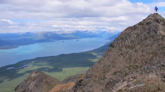
Wrangell-St. Elias National Park & Preserve
Six Yellowstones in one park / Nine of the continent's sixteen highest peaks
America's largest national park dwarfs everything else in the system. You could fit Yellowstone, Yosemite, and Switzerland inside its boundaries and still have room left over. The Bagley Icefield alone covers an area larger than Rhode Island, and Mount St. Elias rises from sea level to 18,008 feet in less than ten miles, one of the steepest elevation gains on Earth. Most of the park remains untrailed wilderness, but the McCarthy Road punches 60 miles into the interior, ending at one of Alaska's most photogenic ghost towns.
Wrangell-St. Elias is so large that its glaciers have glaciers, and some of those glaciers are bigger than entire East Coast parks.
Root Glacier offers one of the few walk-up glacier experiences in Alaska. The trail from Kennicott delivers you to blue ice and crevasse fields without technical gear, though crampons help if you want to explore the surface. The park's size works in your favor even in July: dispersion happens naturally when the landscape absorbs visitors across millions of acres. You'll see other people at McCarthy and Kennicott, but trail encounters drop to near zero once you're a mile from the road.
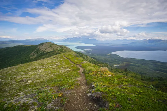
Lake Clark National Park & Preserve
Two active volcanoes / Only reachable by floatplane
Lake Clark sits 100 miles southwest of Anchorage but remains one of the least-visited parks in the system. No roads cross its boundaries, and the only way in is by small plane from Anchorage, Port Alsworth, or Iliamna. The park holds ecosystems that span the full Alaska gradient: coastal rainforest on the east, tundra plateaus in the interior, and volcanic peaks that still vent steam. Mount Redoubt erupted as recently as 2009, sending ash plumes 50,000 feet into the atmosphere and dusting Anchorage in gray powder.
Lake Clark is what Alaska looked like before roads, before trails, before the assumption that wilderness should come with infrastructure.
The park's namesake lake stretches 42 miles through glacial valleys, its turquoise water fed by snowmelt from the Chigmit Mountains. Brown bears fish the salmon streams along the shore, and the Twin Lakes area offers backcountry routes that see single-digit visitor counts each summer. Most people fly in for guided fishing trips or bear viewing, but backpackers willing to navigate off-trail will find solitude that borders on eerie. You can hike for days without seeing another footprint.
Kobuk Valley National Park
25 square miles of sand dunes north of the Arctic Circle / Fewer visitors than a county fair
The Great Kobuk Sand Dunes rise from Arctic tundra like a geographic glitch, 100 feet of shifting sand where you'd expect permafrost and lichen. These aren't high-desert dunes blown in from a distant basin. They're the remnants of glacial grinding, 15,000 years of wind sorting sediment into formations that shouldn't exist this far north. The dunes cover 25 square miles and sit 35 miles above the Arctic Circle, surrounded by boreal forest and caribou migration routes.
Climbing sand dunes in a parka is cognitively dissonant in the best possible way.
The Western Arctic Caribou Herd migrates through Kobuk Valley twice a year, and Onion Portage has recorded human use for 12,000 years, one of the longest continuous archaeological records in North America. You'll fly into Kotzebue and charter a bush plane to the park, landing on the Kobuk River and hiking inland to the dunes. Most visitors come in late summer when the river is warmest and the mosquitoes ease off. The park sees so few people that rangers sometimes go weeks without recording a visitor contact.
Denali National Park & Preserve
North America's tallest peak / One road, six million acres
Denali draws more visitors than any other park on this list, but the numbers lie. The park road stretches 92 miles into the interior, and private vehicles can only drive the first 15. Beyond Savage River, you're on a park shuttle, and the sheer size of the landscape swallows the crowds. Most people ride the bus to Wonder Lake or Eielson Visitor Center, but the backcountry units that flank the road see almost no one. You can step off the bus at any point and hike into terrain that hasn't seen human traffic in months.
Denali's genius is hiding six million acres of wilderness behind a single crowded road.

Mount Healy Overlook Trail offers the park's best accessible hike, climbing 1,700 feet in 2.5 miles to views over the entrance area and the Alaska Range beyond. Grizzlies, caribou, and Dall sheep appear as pale dots on distant ridges, and the tundra rolls out in every direction. The mountain itself hides behind weather more often than not. Locals say you have a 30 percent chance of seeing the summit on any given day, and when it does appear, it dominates the horizon like nothing else on the continent.
Isle Royale National Park
Lake Superior island with 165 miles of trail / No cars, no roads, just forest camps and moose
Isle Royale floats in Lake Superior 56 miles from the Michigan mainland, accessible only by ferry or seaplane. The island measures 45 miles long and nine miles wide, with a backcountry trail system that rivals anything in the Rockies. The difference is solitude. While backpackers jostle for permits in the Tetons or Glacier, Isle Royale's shelters and tent sites rarely fill, even in August. You'll hike through boreal forest and along rocky shorelines, passing shipwrecks and old copper mines, camping in three-sided shelters that face the lake.
Isle Royale feels like the Boundary Waters with trails, or the Appalachian Trail without the crowds.
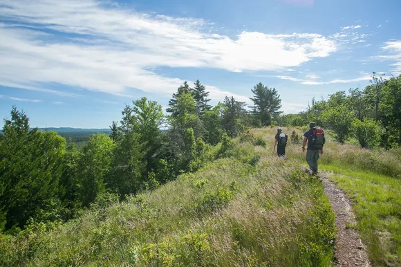
The island's wolf and moose populations have drawn researchers for decades, one of the longest-running predator-prey studies in the world. Moose arrived by swimming from Canada in the early 1900s, and wolves crossed an ice bridge in the late 1940s. The population dynamics swing wildly, and recent wolf reintroductions have stabilized numbers after near-collapse. You'll see moose near trail junctions and along shoreline routes, often close enough to hear them chewing aquatic plants. Greenstone Ridge Trail runs the length of the island, a 40-mile traverse that takes most people four to five days.
North Cascades National Park
300 glaciers three hours north of Seattle / More ice than the rest of the Lower 48 combined
North Cascades holds more glaciers than any other national park outside Alaska, with jagged peaks that rival anything in the Rockies for alpine drama. The North Cascades Highway bisects the park complex, climbing through old-growth forest and past turquoise reservoirs before topping out at Washington Pass. Most visitors drive the highway, stop at the overlooks, and keep moving. The backcountary sees almost no one, even in August.
North Cascades punishes casual visitors and rewards anyone willing to hike past the first mile.
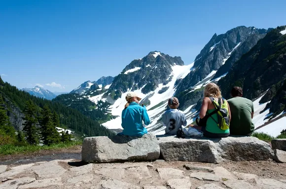
Cascade Pass Trail climbs 1,800 feet in just under four miles, delivering views of glaciated peaks that look more like Alaska than Washington. The pass sits at treeline, and you can continue up Sahale Arm for another 2,000 feet of elevation if you want to stand on snowfields in July. Diablo Lake glows unnatural turquoise from glacial flour, and the Ross Lake area offers flatwater paddling through roadless valleys. The park draws fewer annual visitors than Great Sand Dunes, despite sitting within day-trip range of Seattle and Vancouver.